La cartografía en línea ofrece información sobre nuestra cuenca hidrográfica, incluidos los parques de Conservación Halton y otras propiedades, como la Escarpa del Niágara y el Cinturón Verde, así como nuestra cartografía del Límite de Regulación Aproximado.
En los últimos años, Conservación Halton se ha embarcado en una importante revisión y actualización de nuestra cartografía normativa (por ejemplo, cartografía de riesgos de inundación, cartografía de humedales, cartografía de cursos de agua, etc.). La actualización de los estudios técnicos y la elaboración de modelos, utilizando nuevas herramientas y tecnologías, nos ayudan a comprender mejor la naturaleza y la extensión de los peligros y/o humedales existentes. La cartografía es un proceso dinámico. A medida que avanzan las revisiones y actualizaciones de la cartografía, será necesario perfeccionar la cartografía del Límite de Regulación Aproximado, ya que es posible que se identifiquen o eliminen nuevas zonas peligrosas o reguladas.
PLEASE NOTE: On Febrero 16, 2024, the Province introduced O. Reg., 41/24, which alters the boundaries of CH’s regulated area. Conservation Halton is in the process of updating its Approximate Regulation Limit mapping for Abril 1, 2024. Learn more on our Permitting and Planning page.
The Floodplain Mapping program is responsible for updating and maintaining watershed floodplain mapping, which identifies flood risk and hazards. This information is used to develop approximate regulation limit mapping for purposes of review associated with the Conservation Authorities Act and Ontario Regulation 41/24, as well as used to support flood risk management decisions and communications
El primer paso para reducir el impacto de los daños causados por las inundaciones en una comunidad es disponer de una cartografía que nos ayude a identificar los riesgos de inundación con precisión. Conservación Halton está trabajando con nuestros socios para reducir el riesgo de inundación en nuestras comunidades mediante la actualización de nuestros mapas de llanuras de inundación, algunos de los cuales tienen más de 20 años. Las actualizaciones de los estudios técnicos y la modelización, mediante el uso de nuevas herramientas y tecnologías, nos ayudan a comprender mejor el alcance de los peligros de inundación. A medida que avanzan las revisiones y actualizaciones de los mapas, será necesario perfeccionar la cartografía del Límite de Regulación Aproximado, ya que es posible que se identifiquen nuevas zonas de peligro o reguladas y que se eliminen algunas.
¿Cómo puede participar?
Conservación Halton anima al público a participar en los estudios de cartografía de riesgos de inundación. La participación del público proporciona mayor seguridad y transparencia al programa de cartografía de llanuras de inundación, y se beneficia de recibir observaciones sobre la cuenca de las personas que experimentan estas condiciones de la cuenca.
Organizamos sesiones de participación pública sobre estudios cartográficos de llanuras de inundación para notificar al público y a las partes interesadas que se está realizando un estudio en su zona y para compartir información sobre el proceso de estudio y los borradores de las actualizaciones cartográficas para su revisión y aportación. Las notificaciones de los estudios cartográficos de las llanuras de inundación y las actualizaciones de la participación pública se publican en los periódicos de la comunidad y se publican en el sitio web de Conservación Halton y en las redes sociales. También puede solicitar que se le añada a la lista de contactos de correo electrónico del estudio para recibir notificaciones directas.
Conservation Halton developed a protocol to establish at what point in the mapping update process will the draft data or mapping be considered “best available information” for understanding the extent of the hazard, assessing potential risk to life and property, identifying potential interference to a wetland, identifying areas requiring further analysis, making decisions when development is contemplated in hazardous or regulated areas and administering the Ontario Conservation Authorities Act and Ontario Regulation 41/24. The Mapping Implementation Protocol establishes the key stages in the mapping update and study process, what data will be used at each stage of the process, how the data will be presented in online mapping, when the data can be used for administering the Conservation Authorities Act and Ontario Regulation 41/24, and when public and stakeholder engagement will occur.
The Conservation Halton Board endorsed the Mapping Implementation Protocol Report for use on Noviembre 26, 2021.
Estudios cartográficos recientes:
 Watercourse crossing structures like bridges and culverts can significantly impact flooding along rivers and creeks. To better understand the impacts of these structures, Conservation Halton collected data within the Bronte Creek watershed from Mayo 2023 to Febrero 2024. This data will inform future updates to Conservation Halton’s flood hazard mapping.
Flood hazard mapping is an important tool that supports Conservation Halton’s regulatory, planning, and flood forecasting programs. This information also supports municipal emergency management planning, and flood mitigation and infrastructure design.
Public engagement sessions and opportunities for the public to learn more about Conservation Halton’s flood hazard mapping for Bronte Creek will occur once a study formally begins.
This structure survey project received funding from the Government of Canada through the Flood Hazard Identification and Mapping Program (FHIMP), a component of Canada’s National Adaptation Strategy. The FHIMP is led by Natural Resources Canada (NRCan) and provides funding to Provincial and Territorial governments in partnership with Environment and Climate Change Canada and Public Safety.
Project geodatabases are available upon request.
If you have any questions, comments or concerns, please email floodplainmapping@hrca.on.ca.
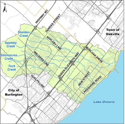 Conservation Halton has updated flood hazard mapping for Tuck, Shoreacres, Appleby, and Sheldon Creeks in your community.
Flood hazard mapping is an important tool that supports Conservation Halton’s regulatory, planning and flood forecasting and warning programs, as well as municipal emergency management, flood mitigation, and infrastructure design. Advances in technology allow us to understand flood risks and develop better flood hazard mapping.
Flood hazards include floodplains and spills. A floodplain is an area of land that is flooded with water by a nearby creek or lake during large storms. Spills occur when flood waters leave the valley and floodplain and “spill” into surrounding lands, rejoining the watercourse at a distance downstream or moving into another watershed.
One of Conservation Halton’s top priorities is to protect life and property from natural hazards and updating hazard mapping is one of the ways we do that.
In 2021, Conservation Halton retained the engineering consulting firm WSP, to update the flood hazard modelling and mapping for Tuck, Shoreacres, Appleby and Sheldon Creeks which cross through parts of east Burlington and southwest Oakville (referred to as ‘East Burlington Creeks Flood Hazard Mapping Study’). Updated mapping and modelling provides Conservation Halton, municipalities, the public, and stakeholders with a current understanding of the magnitude and extent of riverine flood hazards in this area. The study also provides background information and technical details about how the riverine flood hazard modelling and mapping was updated.
As part of this study, Conservation Halton hosted two public engagement sessions. The first engagement session occurred in Octubre 2021 to provide notification of study commencement. This engagement session also provided an opportunity for property owners, residents and other stakeholders to ask questions and share feedback. Draft final mapping was shared during the second virtual engagement session held on Junio 6, 2023.
Presentation material from the final public engagement session is available here: East Burlington Creeks Food Hazard Mapping – Final Consultation.
If you have any questions, comments or concerns, please email floodplainmapping@hrca.on.ca.

Updates to technical studies and new flood hazard modelling can help us better understand the nature and extent of existing flood hazards. These updates can also result in changes to hazard and conservation authority regulation mapping.
The City of Burlington recently completed a Phase 2 Flood Hazard and Scoped Stormwater Management Assessment for downtown Burlington and the Burlington GO Major Transit Station Area (MTSA). The Phase 2 study is considered the best available information for decision making when development is contemplated in hazard lands.
Conservation Halton’s approximate regulation limit mapping has been updated to reflect the Phase 2 study findings.
Under the Conservation Authorities Act and Ontario Regulation 41/24, Conservation Halton regulates all watercourses, valleylands, wetlands, Lake Ontario and Burlington Bay shoreline and hazardous lands, as well as lands adjacent to these features. Permission is required from Conservation Halton to undertake development within these areas.
| For more information about Conservation Halton’s regulated areas and your property, please contact:
Email: floodplainmapping@hrca.on.ca Phone: 905-336-1158 ext. 2296 |
For more information about the Phase 2 Study, please visit:
http://getinvolvedburlington.ca/mtsa Email: mtsa@burlington.ca | Phone: 905-335-7600 ext. 7426 |
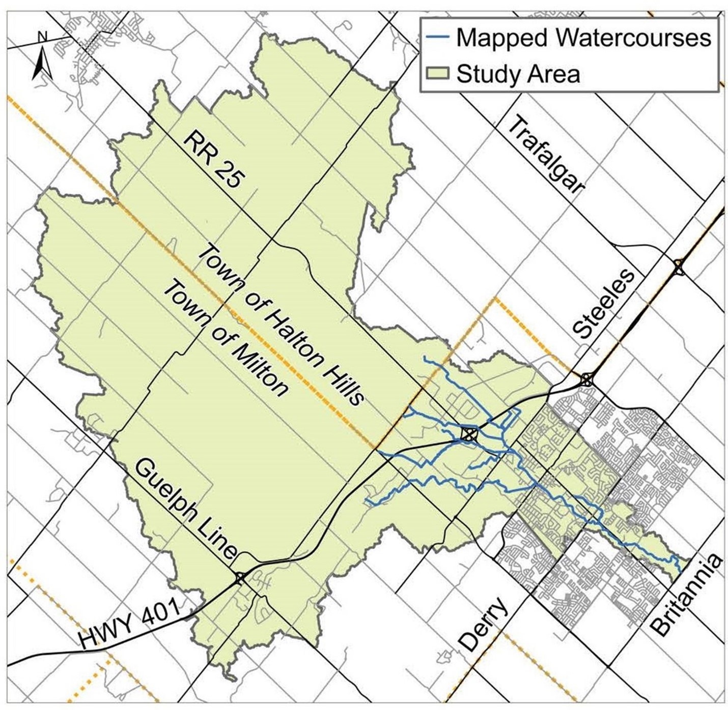 Conservation Halton has retained consulting and engineering company, Greck and Associates, to update flood hazard mapping and modelling for the West Branch of Sixteen Mile Creek in the Town of Milton. Advances in technology allows us to better understand flood hazards and to develop more accurate floodplain mapping. One of Conservation Halton’s top priorities is to protect life and property from natural hazards and updating flood hazard mapping is one of the ways we do that. An important part of the process of updating flood hazard mapping is to inform and engage with residents and other stakeholders in the study area.
Flood hazard mapping is used by Conservation Halton and municipal partners to identify areas that may be susceptible to riverine or shoreline flooding, and to inform flood forecasting, emergency response, community planning, infrastructure upgrades and other flood prevention efforts. Flood hazards include floodplains and spills. A floodplain is an area of land that is flooded by a nearby creek or lake during large storms. Spills occur when flood waters leave the valley and floodplain and “spill” into surrounding lands, rejoining the watercourse at a distance downstream or moving into another watershed.
As part of this study, Conservation Halton hosted three public engagement sessions. The first engagement session occurred in Octubre 2019 to announce the study. A second engagement session in Marzo 2020 presented high-level draft results. The final engagement session in Febrero 2023 shared the detailed draft final mapping. Presentation material from the final public engagement session is available here: Urban Milton Flood Hazard Mapping—Final Consultation.
If you have any questions, comments or concerns, please email floodplainmapping@hrca.on.ca.