Natural hazards, like flooding and erosion from extreme rainfall or snowmelt, can be dangerous for people and cause damage to properties, infrastructure and nature. Conservation Halton provides a flood forecasting, management and operations program to reduce the risk of these natural hazards from having an impact on our community through prevention, prediction, protection and preparedness.
Prevention
The Permitting and Planning department at Conservation Halton works with our municipal partners to support community development that is safe and sustainable. Section 28 of the Conservation Authorities Act enables conservation authorities to develop regulations for certain activities in areas where public health and safety would be at risk because of naturally occurring processes (e.g., flooding, erosion) or where activities could either create a natural hazard or aggravate a natural hazard that already exists.
Prediction
Conservation Halton is constantly monitoring weather and watershed conditions, in collaboration with other conservation authorities, the Ontario Ministry of Natural Resources, and Environment Canada. (Click here for real-time environmental monitoring of air temperature, water temperatures and precipitation amounts in the Conservation Halton watershed.) When flooding is forecasted, Conservation Halton issues flood messages to municipal emergency management, emergency medical response, school boards, police and media.
Protection
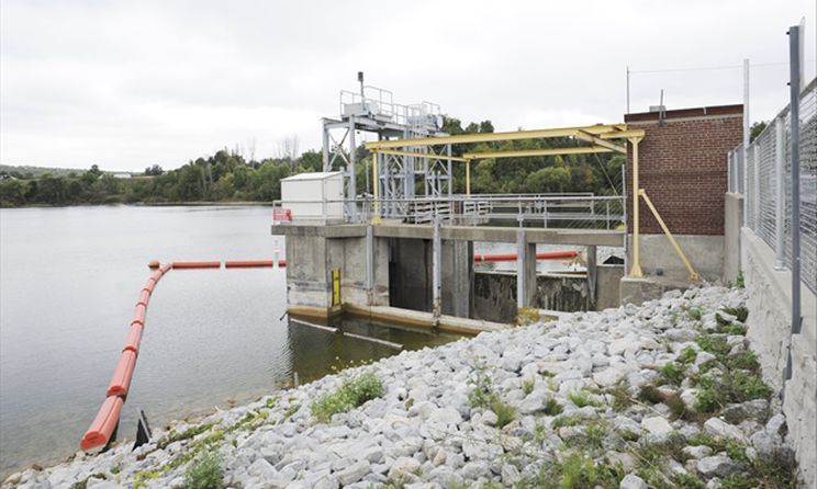
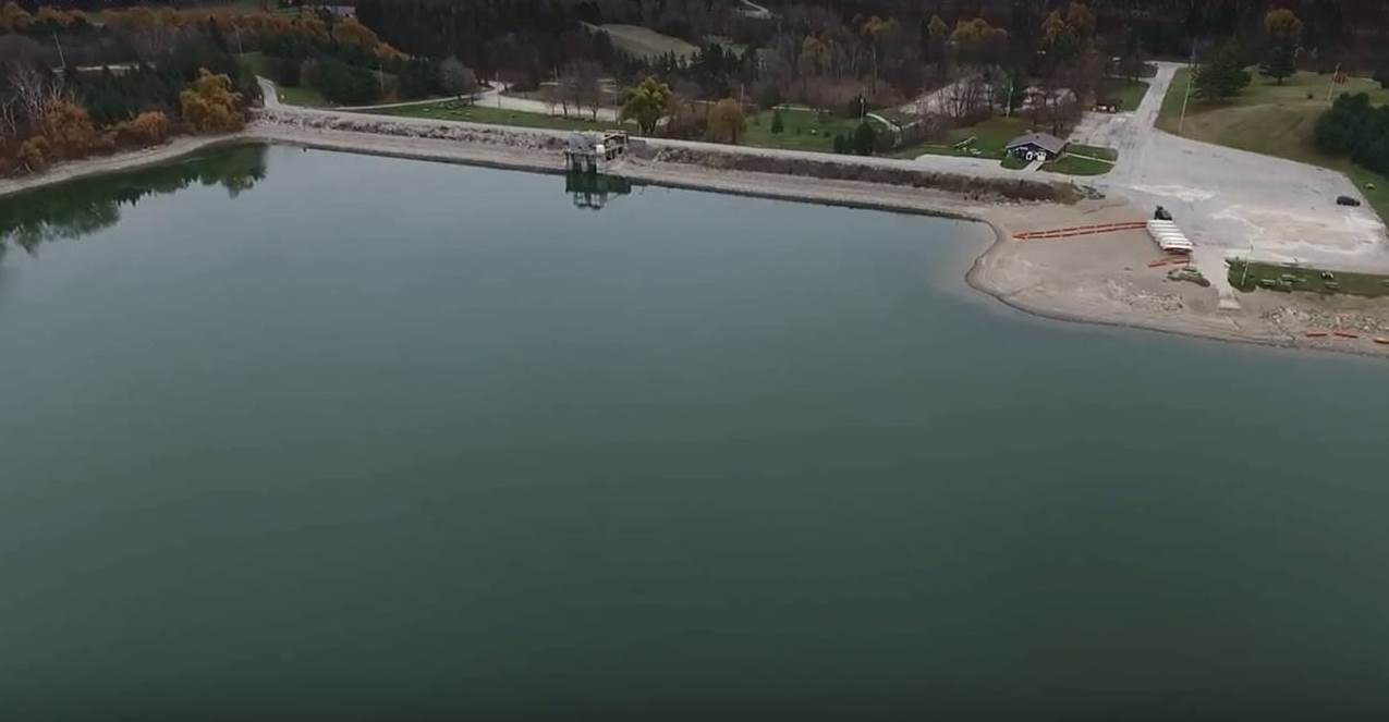
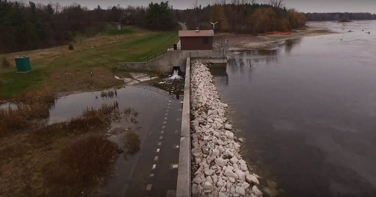
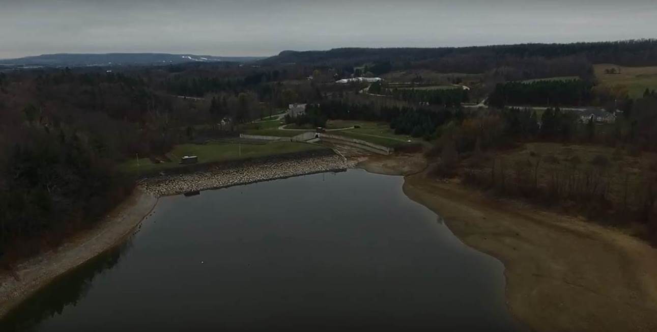
Conservation Halton operates and maintains four major flood control dams (Kelso, Hilton Falls, Scotch Block and Mountsberg) and more than 12 kilometers of flood channels (Sixteen Mile Creek through Milton, Morrison-Wedgewood diversion in Oakville and the Hager-Rambo diversion in Burlington). The dams are designed to control flooding and augment water flow during periods of low water. The flood control channels are designed to convey, and in some cases divert, flood water away from flood-prone areas.
Preparedness
If a flood message is issued in your area, it is important to follow instructions of emergency response authorities. We would also recommend that you consider, in advance, what you can do to be prepared for flood emergencies. Halton Region has compiled information on what you can do before, during, and after a flood to protect yourself and your family, and Environment Canada also has information on what you can do before, during, and after a flood.
Flooding and erosion are two of the natural hazards of key concern in the Conservation Halton watershed. Flooding is what happens when the water levels of a creek, stream, river or lake cover the adjacent area of land, known as the floodplain. Erosion is a natural process that occurs during floods, or even when water levels rise but do not overflow, but an increased amount of erosion can weaken the stability of stream banks and other slopes.
These natural hazards can cause property damage, personal injury and loss of life. As our communities continue to grow and expand, and as climate change continues to increase the frequency and severity of storm events, flood control in the Conservation Halton watershed is more important than ever.
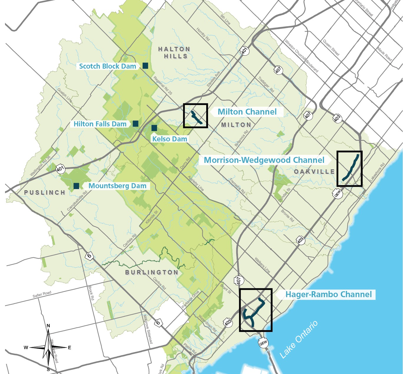
Conservation Halton operates and maintains four major flood control dams, which were built in direct response to the devastation of Hurricane Hazel (October 1954). Most of these facilities were constructed in the 1960s and 1970s. Since this time, flood management has shifted from expensive, engineered structures, like dam and channels, to more a passive approach, including land acquisition and development regulation.
Kelso Dam
Kelso Dam was the first flood control dam constructed within the jurisdiction and was built in 1962. It operates in conjunction with the Hilton Falls Dam and Reservoir. It is operated to provide flood protection to downstream areas within the Town of Milton during spring melt, as well as rainfall and snowmelt events. Kelso Dam provides low flow augmentation in summer months to support aquatic habitat in the downstream Sixteen Mile Creek. It also allows visitors to Kelso to enjoy recreational opportunities like swimming and non-motorized boating.
Hilton Falls Dam
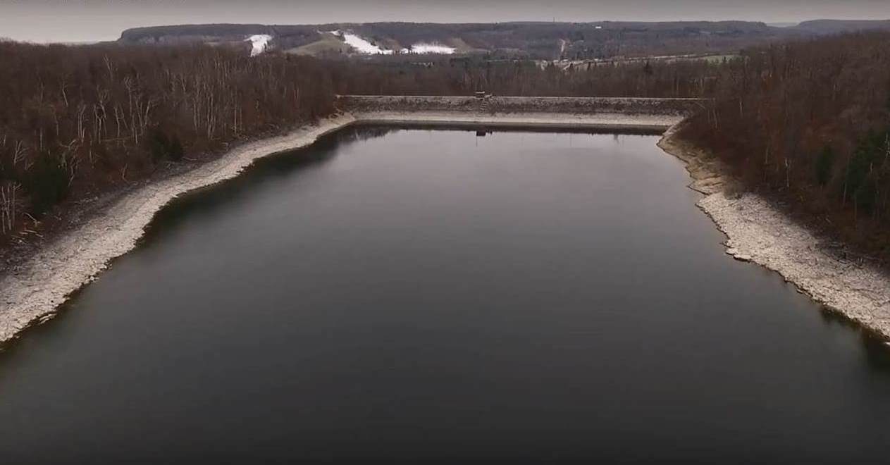
The Hilton Falls Dam and Reservoir was constructed in 1974. It operates in conjunction with the Kelso Reservoir to provide flood protection to downstream areas within the Town of Milton during spring melt, as well as rainfall and snowmelt events.. Hilton Falls is also used to augment flows into the Kelso reservoir during drier summer months by storing upstream runoff during the spring and releasing it at a pre-determined rate. The level of flood protection during winter months is quite high because when holding levels are lower, but the level of flood protection is reduced during summer, due to higher reservoir levels, which reduce available active flood storage.
Mountsberg Dam
The Mountsberg Dam and Reservoir was constructed in 1967. It is operated to provide flood protection to downstream areas within Lawson Trailer Park and the Town of Carlisle during spring melt, as well as rainfall and snowmelt events. Mountsberg is also used to augment low flows in downstream Mountsberg Creek and the Bronte Creek system during drier summer months by storing upstream runoff during the spring and releasing at a pre-determined rate. The reservoir also provides recreational opportunities, like fishing and non-motorized boating.
Scotch Block Dam
The Scotch Block Dam and Reservoir was constructed in 1971. It is operated to provide flood protection to downstream areas within the villages of Mansewood and Hornby during spring melt, as well as rainfall and snowmelt events. Scotch Block is also used to augment flows in Middle Sixteen Mile Creek during drier summer months by storing upstream runoff during the spring and releasing at a pre-determined rate. The level of flood protection during winter months is quite high because when holding levels are lower, but the level of flood protection is reduced during summer, due to higher reservoir levels, which reduce available active flood storage.
Conservation Halton operates and maintains three flood control channels. The channels were built in the late 1960’s and 1970’s to move water through our communities and into Lake Ontario as quickly as possible. Since this time, the way that we design our communities has changed. Today, our communities include stormwater ponds and space for creeks to flow, naturally, so that excess water can be stored and released over time after a rain event.
Hager-Rambo
The Hager-Rambo Flood Channel was completed in 1976 and is almost 4 km in length. It is intended to ease local flooding in residential areas within the City of Burlington. The Hager-Rambo diverts the flow of the upper Hager and Rambo Creeks west to Indian Creek before emptying into Lake Ontario.
Milton
The Milton Flood Channel was built in five phases, the last coming in 1979. It is 3 km in length and conveys flood waters of the Sixteen Mile Creek safely through the historic downtown area of the Town of Milton.
Morrison-Wedgewood
The Morrison-Wedgewood Channel was the first flood channel built by Conservation Halton in 1967 in the Town of Oakville. It was added to in 1969. This channel is just over 4 km long and diverts waters from residential areas north of the Queen Elizabeth Way, west to the Sixteen Mile Creek, and away from residential areas south of the QEW.
The first step to reducing the impact of flood damage within a community is to have mapping that helps us identify flood hazards, accurately. Conservation Halton is working with our partners to reduce flood risk in our communities by updating out floodplain maps, some of which are more than 20 years old. Updates to technical studies and modelling, using new tools and technologies, help us to better understand the extent of flood hazards. As mapping reviews and updates progress, refinements to Approximate Regulation Limit mapping will be necessary, as additional hazard or regulated areas may be identified and some may be removed.
How can you get involved?
Conservation Halton encourages the public to participate in flood hazard mapping studies. Public involvement provides greater certainty and transparency for the floodplain mapping program, and it benefits from receiving observations about the watershed from the people who experience these watershed conditions.
We host public engagement sessions on floodplain mapping studies to notify the public and stakeholders that a study is occurring in their area and to share information on the study process and draft mapping updates for review and input. Floodplain mapping study notifications and updates on public engagement are published in community newspapers and posted on the Conservation Halton website and social media. You can also request to be added to the email contact list for the study to receive direct notifications.
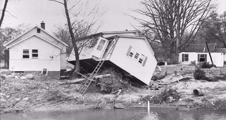
Hurricane Hazel in 1954, and the catastrophic flooding that it caused, was the driving force for the creation of conservation authorities in Ontario. Within the province, 81 people lost their lives and 4,000 families were displaced from their homes. Following the destruction and devastation of Hurricane Hazel, regulations and policies to prevent home construction and other development in ravines and floodplains were implemented to protect us from similar tragedy.