Natural hazards, like flooding and erosion from extreme rainfall or snowmelt, can be dangerous for people and cause damage to properties, infrastructure and nature. Conservation Halton provides a flood forecasting, management and operations program to reduce the risk of these natural hazards from having an impact on our community through prevention, prediction, protection and preparedness.
روک تھام
کنزرویشن ہلٹن میں اجازت دینے اور منصوبہ بندی کا محکمہ ہمارے میونسپل شراکت داروں کے ساتھ مل کر کمیونٹی کی ترقی میں مدد کرتا ہے جو محفوظ اور پائیدار ہے۔ کنزرویشن اتھارٹیز ایکٹ کی دفعہ 28 تحفظ حکام کو ان علاقوں میں کچھ سرگرمیوں کے ضوابط تیار کرنے کے قابل بناتی ہے جہاں قدرتی طور پر ہونے والے عمل (جیسے سیلاب، کٹاؤ) یا جہاں سرگرمیاں یا تو قدرتی خطرہ پیدا کر سکتی ہیں یا قدرتی خطرہ بڑھا سکتی ہیں جو پہلے سے موجود ہے۔
پیشن گوئی
Conservation Halton is constantly monitoring weather and watershed conditions, in collaboration with other conservation authorities, the Ontario Ministry of Natural Resources, and Environment Canada. (Click here for real-time environmental monitoring of air temperature, water temperatures and precipitation amounts in the Conservation Halton watershed.) When flooding is forecasted, Conservation Halton issues flood messages to municipal emergency management, emergency medical response, school boards, police and media.
پناہ
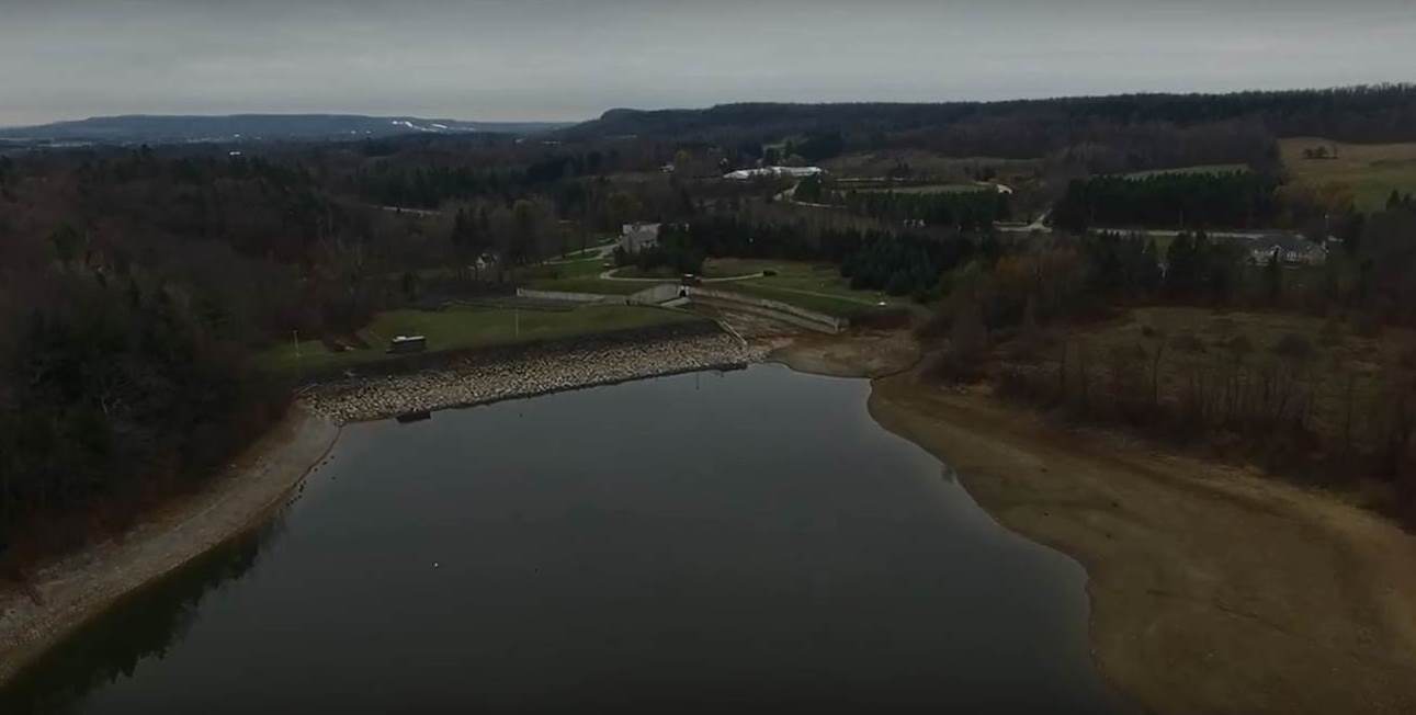
کنزرویشن ہلٹن چار بڑے سیلاب کنٹرول ڈیموں (کیلسو، ہلٹن آبشار، اسکاچ بلاک اور ماؤنٹسبرگ) اور 12 کلومیٹر سے زیادہ سیلاب چینلز (ملٹن کے ذریعے سولہ میل کریک، اوک ویل میں موریسن-ویج ووڈ موڑ اور برلنگٹن میں ہیگر-ریمبو موڑ) چلاتا اور برقرار رکھتا ہے۔ ڈیموں کو سیلاب پر قابو پانے اور کم پانی کے دوران پانی کے بہاؤ کو بڑھانے کے لئے ڈیزائن کیا گیا ہے۔ سیلاب پر قابو پانے والے چینلوں کو یہ بتانے کے لئے ڈیزائن کیا گیا ہے اور بعض صورتوں میں سیلاب زدہ علاقوں سے سیلاب کا پانی دور کر دیا جاتا ہے۔
Preparedness
If a flood message is issued in your area, it is important to follow instructions of emergency response authorities. We would also recommend that you consider, in advance, what you can do to be prepared for flood emergencies. Halton Region has compiled information on what you can do before, during, and after a flood to protect yourself and your family, and Environment Canada also has information on what you can do before, during, and after a flood.
Flooding and erosion are two of the natural hazards of key concern in the Conservation Halton watershed. Flooding is what happens when the water levels of a creek, stream, river or lake cover the adjacent area of land, known as the floodplain. Erosion is a natural process that occurs during floods, or even when water levels rise but do not overflow, but an increased amount of erosion can weaken the stability of stream banks and other slopes.
These natural hazards can cause property damage, personal injury and loss of life. As our communities continue to grow and expand, and as climate change continues to increase the frequency and severity of storm events, flood control in the Conservation Halton watershed is more important than ever.
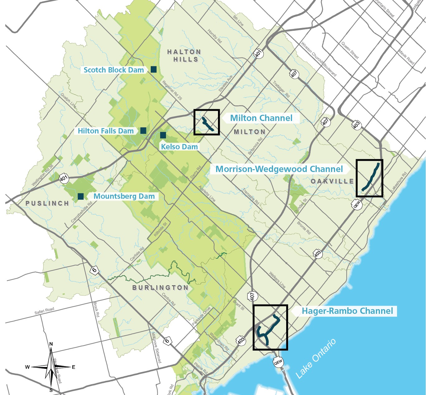
کنزرویشن ہلٹن سیلاب پر قابو پانے والے چار بڑے ڈیمچلاتا اور برقرار رکھتا ہے، جو سمندری طوفان ہیزل (اکتوبر 1954) کی تباہی کے براہ راست جواب میں تعمیر کیے گئے تھے۔ ان میں سے زیادہ تر سہولیات ١٩٦٠ اور ١٩٧٠ کی دہائی میں تعمیر کی گئیں۔ اس وقت سے سیلاب کا انتظام ڈیم اور چینلز جیسے مہنگے، انجینئرڈ ڈھانچوں سے زمین کے حصول اور ترقیاتی ضابطوں سمیت مزید غیر فعال نقطہ نظر کی طرف منتقل ہو گیا ہے۔
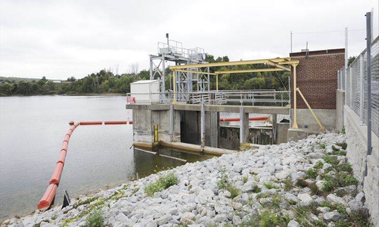
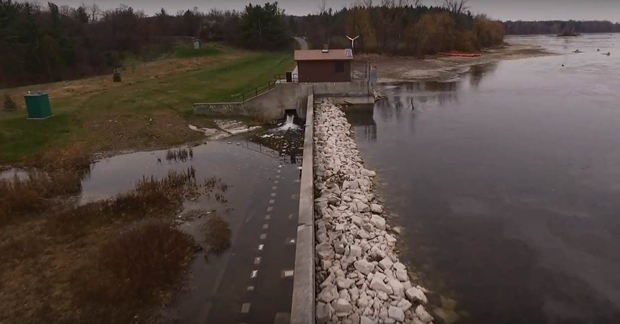
کیلسو ڈیم
Kelso Dam was the first flood control dam constructed within the jurisdiction and was built in 1962. It operates in conjunction with the Hilton Falls Dam and Reservoir. It is operated to provide flood protection to downstream areas within the Town of Milton during spring melt, as well as rainfall and snowmelt events. Kelso Dam provides low flow augmentation in summer months to support aquatic habitat in the downstream Sixteen Mile Creek. It also allows visitors to Kelso to enjoy recreational opportunities like swimming and non-motorized boating.
ہلٹن آبشار ڈیم
The Hilton Falls Dam and Reservoir was constructed in 1974. It operates in conjunction with the Kelso Reservoir to provide flood protection to downstream areas within the Town of Milton during spring melt, as well as rainfall and snowmelt events.. Hilton Falls is also used to augment flows into the Kelso reservoir during drier summer months by storing upstream runoff during the spring and releasing it at a pre-determined rate. The level of flood protection during winter months is quite high because when holding levels are lower, but the level of flood protection is reduced during summer, due to higher reservoir levels, which reduce available active flood storage.
ماؤنٹس برگ ڈیم
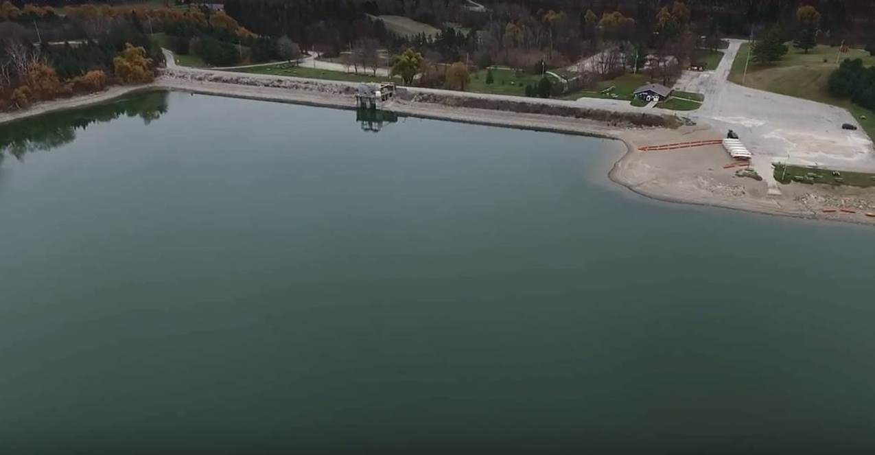
The Mountsberg Dam and Reservoir was constructed in 1967. It is operated to provide flood protection to downstream areas within Lawson Trailer Park and the Town of Carlisle during spring melt, as well as rainfall and snowmelt events. Mountsberg is also used to augment low flows in downstream Mountsberg Creek and the Bronte Creek system during drier summer months by storing upstream runoff during the spring and releasing at a pre-determined rate. The reservoir also provides recreational opportunities, like fishing and non-motorized boating.
Scotch Block Dam
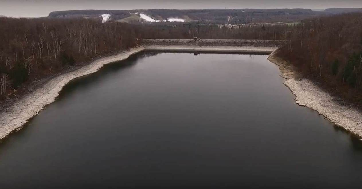
The Scotch Block Dam and Reservoir was constructed in 1971. It is operated to provide flood protection to downstream areas within the villages of Mansewood and Hornby during spring melt, as well as rainfall and snowmelt events. Scotch Block is also used to augment flows in Middle Sixteen Mile Creek during drier summer months by storing upstream runoff during the spring and releasing at a pre-determined rate. The level of flood protection during winter months is quite high because when holding levels are lower, but the level of flood protection is reduced during summer, due to higher reservoir levels, which reduce available active flood storage.
کنزرویشن ہلٹن سیلاب پر قابو پانے کے تین چینلچلاتا اور برقرار رکھتا ہے۔ یہ چینلز 1960 اور 1970 کی دہائی کے اواخر میں تعمیر کیے گئے تھے تاکہ ہماری کمیونٹیز کے ذریعے پانی کو منتقل کیا جا سکے اور جلد از جلد جھیل اونٹاریو میں منتقل کیا جا سکے۔ اس وقت سے ہم اپنی کمیونٹیز کو ڈیزائن کرنے کا طریقہ بدل گیا ہے۔ آج ہماری کمیونٹیز میں طوفانی پانی کے تالاب اور کھاڑیوں کے بہاؤ کے لئے جگہ شامل ہے، قدرتی طور پر، تاکہ بارش کے واقعے کے بعد اضافی پانی کو ذخیرہ کیا جا سکے اور وقت کے ساتھ چھوڑا جا سکے۔
ہیگر ریمبو
ہیگر ریمبو فلڈ چینل 1976 میں مکمل ہوا تھا اور اس کی لمبائی تقریبا 4 کلومیٹر ہے۔ اس کا مقصد برلنگٹن شہر کے اندر رہائشی علاقوں میں مقامی سیلاب کو کم کرنا ہے۔ ہیگر-ریمبو جھیل اونٹاریو میں خالی ہونے سے پہلے بالائی ہیگر اور ریمبو کریک کے بہاؤ کو مغرب میں انڈین کریک کی طرف موڑ دیتا ہے۔
ملٹن
ملٹن فلڈ چینل پانچ مرحلوں میں تعمیر کیا گیا تھا، آخری 1979 میں آ رہا تھا. اس کی لمبائی 3 کلومیٹر ہے اور یہ ملٹن شہر کے تاریخی شہر کے علاقے سے سولہ میل کریک کے سیلاب کے پانی کو بحفاظت پہنچاتا ہے۔
موریسن ویج ووڈ
موریسن ویج ووڈ چینل پہلا سیلاب چینل تھا جسے کنزرویشن ہلٹن نے 1967 میں اوک ویل کے قصبے میں تعمیر کیا تھا۔ اسے ١٩٦٩ میں شامل کیا گیا تھا۔ یہ چینل صرف 4 کلومیٹر سے زیادہ لمبا ہے اور ملکہ الزبتھ وے کے شمال میں رہائشی علاقوں، مغرب میں سولہ میل کریک اور کیو ای ڈبلیو کے جنوب میں رہائشی علاقوں سے دور پانی کا رخ موڑتا ہے۔
ایک کمیونٹی کے اندر سیلاب سے ہونے والے نقصان کے اثرات کو کم کرنے کا پہلا قدم نقشہ سازی کرنا ہے جو ہمیں سیلاب کے خطرات کی درست شناخت کرنے میں مدد کرتا ہے۔ کنزرویشن ہلٹن ہمارے شراکت داروں کے ساتھ مل کر سیلاب کے میدانی نقشوں کو اپ ڈیٹ کرکے ہماری کمیونٹیز میں سیلاب کے خطرے کو کم کرنے کے لئے کام کر رہا ہے جن میں سے کچھ 20 سال سے زیادہ پرانے ہیں۔ تکنیکی مطالعات اور ماڈلنگ کی اپ ڈیٹس، نئے آلات اور ٹیکنالوجیز کا استعمال کرتے ہوئے، ہمیں سیلاب کے خطرات کی حد کو بہتر طور پر سمجھنے میں مدد کرتی ہیں۔ جیسے جیسے نقشہ سازی کے جائزے اور اپ ڈیٹس پیش رفت ہوتی ہے، تقریبا ریگولیشن کی حد کی نقشہ سازی میں تطہیر ضروری ہوگی، کیونکہ اضافی خطرے یا منظم علاقوں کی شناخت کی جاسکتی ہے اور کچھ کو ہٹایا جاسکتا ہے۔
آپ اس میں کیسے شامل ہو سکتے ہیں؟
کنزرویشن ہلٹن عوام کو سیلاب کے خطرے کی نقشہ سازی کے مطالعے میں حصہ لینے کی ترغیب دیتا ہے۔ عوامی شمولیت فلڈ پلین میپنگ پروگرام کے لئے زیادہ یقینی اور شفافیت فراہم کرتی ہے، اور اس سے ان لوگوں سے واٹر شیڈ کے بارے میں مشاہدات حاصل کرنے سے فائدہ ہوتا ہے جو ان واٹر شیڈ حالات کا تجربہ کرتے ہیں۔
ہم فلڈ پلین میپنگ مطالعات پر عوامی مشغولیت کے اجلاسوں کی میزبانی کرتے ہیں تاکہ عوام اور اسٹیک ہولڈرز کو مطلع کیا جاسکے کہ ان کے علاقے میں ایک مطالعہ ہو رہا ہے اور جائزہ اور ان پٹ کے لئے مطالعاتی عمل اور مسودہ نقشہ سازی اپ ڈیٹس کے بارے میں معلومات کا اشتراک کریں۔ فلڈ پلین میپنگ مطالعاتی نوٹیفکیشن اور عوامی مشغولیت سے متعلق اپ ڈیٹس کمیونٹی اخبارات میں شائع کی جاتی ہیں اور کنزرویشن ہلٹن ویب سائٹ اور سوشل میڈیا پر پوسٹ کی جاتی ہیں۔ براہ راست اطلاعات حاصل کرنے کے لئے مطالعہ کے لئے آپ ای میل رابطہ فہرست میں شامل کرنے کی درخواست بھی کرسکتے ہیں۔
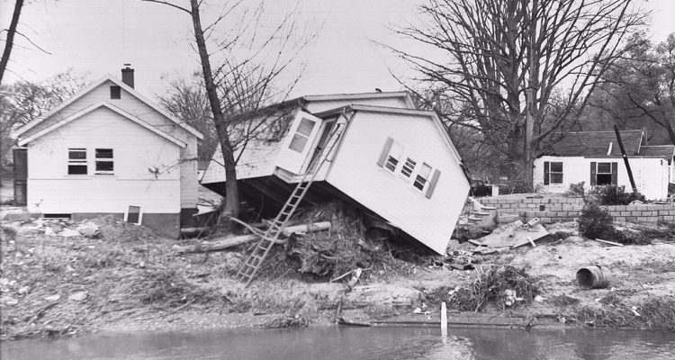
Hurricane Hazel in 1954, and the catastrophic flooding that it caused, was the driving force for the creation of conservation authorities in Ontario. Within the province, 81 people lost their lives and 4,000 families were displaced from their homes. Following the destruction and devastation of Hurricane Hazel, regulations and policies to prevent home construction and other development in ravines and floodplains were implemented to protect us from similar tragedy.