Project Media
Drumquin Park Phase 2 Press Release (August 18, 2021)
Drumquin Park Press Release (July 30, 2019)
June 18, 2018: Inside Halton (Groundbreaking)
July 19, 2018: Inside Halton (Mudpuppies)
August 9, 2019: Inside Halton (Completion)
July 30, 2020: TVO Kids – FishHeads
Restoring Drumquin Park
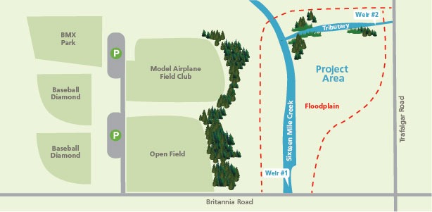
Conservation Halton, in partnership with Milton, is carrying out an ecological restoration project on Sixteen Mile Creek at Drumquin Park.
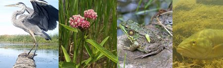
The project objectives are to restore the natural functions of the creek, improve the quality of fish habitat, remove instream fish barriers, and increase biodiversity in the floodplain, which overall enhances the health of the entire Sixteen Mile Creek watershed.
Once complete, this project will see the creek and floodplain returned to more of a natural state, providing a healthier watershed for wildlife and Halton residents.
The Drumquin Park Restoration Project will be executed in two phases to better manage short-term stress on the environment.
This restoration initiative significantly enhances natural areas to ensure they are more resilient to the impact of climate change and provide improved benefits to local residents. The restoration and enhancement of Sixteen Mile Creek will improve the Halton Region Natural Heritage System as well as provide many other enhancements and services to the health of the entire watershed.
Restoration enhancements within the stream channel will improve surface water quality by reducing suspended sediment, E. coli, other waterborne bacteria and lowering water temperature. It also will improve fish passage to upstream areas of Sixteen Mile Creek. Enhancements within the floodplain will improve the function of the floodplain by retaining more water during storm events while also creating ephemeral wetlands for waterfowl and amphibian habitat. By removing the weirs, there will be a reduction in the potential risk of failure of the structure, which would cause significant impacts such as in-stream and bank erosion.
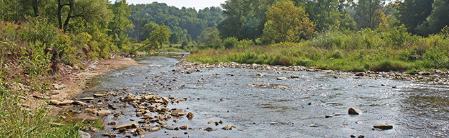
The section of Sixteen Mile Creek within Drumquin Park has changed dramatically over the last 60 years. Historically, Sixteen Mile Creek meandered gently through Drumquin Park with narrow creek banks. Since that time, the channel was straightened and widened, and a weir was constructed in the creek.
The weir created a barrier to fish trying to reach upstream portions of Sixteen Mile Creek and encouraged ponding of the creek upstream of the weir. In addition to the weir being built, the portion of creek immediately upstream of this weir was dug out, widened and straightened. The combination of the installation of the weir, and change of creek channel shape, created slower flows and ponding compared to unaltered downstream sections of Sixteen Mile Creek. This reduces the type of habitat and stream flow function that should be present at this location. The floodplain of Sixteen Mile Creek was also altered by human disturbance and changed from being forested to existing as a meadow.
The weir no longer serves the interests of the public. The decision to remove the weir was reached when analysis outlined that the benefits of the barrier no longer outweighed the harm it imposes.

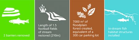
Restoration plans for Sixteen Mile Creek include the removal of two weirs, which are barriers to water flow and passage of fish and wildlife. After the weirs are removed, fish will be able to travel upstream to reach habitat in the upper watershed at times of the year that are inaccessible today. The flow of the creek will then be unrestricted, improving the health of the creek by restoring natural flow.
Another aspect of the restoration plan is to restore the channel shape of Sixteen Mile Creek as it passes through Drumquin Park to a more natural width, depth and path of flow. The restoration of the channel shape will contribute to restoring healthy habitat of deep pools and faster flowing water for fish as well as returning natural flow to Sixteen Mile Creek. This will help to stabilize the banks of the creek to reduce erosion and improve the stability of the system to withstand the impacts of climate change related to high flows and low water. By removing the weirs and improving the channel, surface water temperature will also decrease, providing cooler water downstream.
Finally, restoration plans for the floodplain include the transformation of the cultural meadow to a pit and mound forest, which would have been more characteristic of this area before the land was cleared. To create this pit and mound forest, construction practices will involve digging small pits and creating small earth mounds throughout the floodplain. After the pit and mounds are created, the area will be planted with native trees. In addition to the ecosystem being enhanced by the planting of trees within the floodplain, the dug pits provide many enhancements to the floodplain. The pits will act as small wetlands, providing habitat for birds and amphibians while also reducing runoff from storm events by holding water. By holding water, the pits decrease the amount of runoff that can cause erosion.
This project supports and implements initiatives which contribute to the following:
- Conservation Halton Strategic Plan
- Halton Region Natural Heritage System
- Milton Official Plan
- Milton Urban Forest Management Strategy
- Milton Community Services Master Plan
- Ontario Greenbelt Natural Heritage System
- Silver Shiner Species at Risk Recovery