Natural hazards, like flooding and erosion from extreme rainfall or snowmelt, can be dangerous for people and cause damage to properties, infrastructure and nature. Conservation Halton provides a flood forecasting, management and operations program to reduce the risk of these natural hazards from having an impact on our community through prevention, prediction, protection and preparedness.
منع
يعمل قسم التصاريح والتخطيط في Conservation Halton مع شركائنا البلديين لدعم تنمية المجتمع الآمن والمستدام. تمكن المادة 28 من قانون سلطات الحفظ سلطات الحفظ من وضع لوائح لأنشطة معينة في المناطق التي تكون فيها الصحة والسلامة العامتان في خطر بسبب العمليات التي تحدث بشكل طبيعي (مثل الفيضانات والتآكل) أو حيث يمكن للأنشطة إما أن تخلق خطرا طبيعيا أو تؤدي إلى تفاقم خطر طبيعي موجود بالفعل.
التنبؤ
Conservation Halton is constantly monitoring weather and watershed conditions, in collaboration with other conservation authorities, the Ontario Ministry of Natural Resources, and Environment Canada. (Click here for real-time environmental monitoring of air temperature, water temperatures and precipitation amounts in the Conservation Halton watershed.) When flooding is forecasted, Conservation Halton issues flood messages to municipal emergency management, emergency medical response, school boards, police and media.
حماية
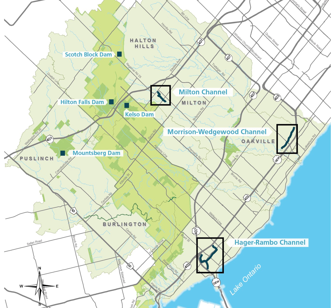
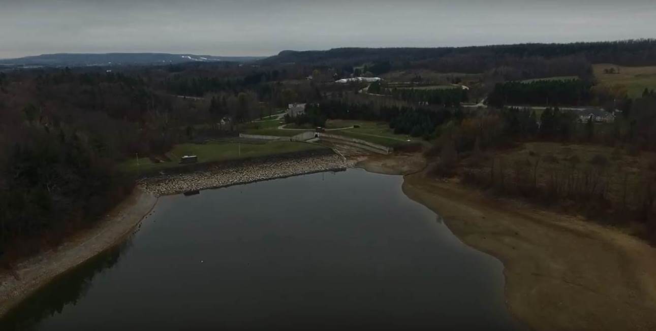
تقوم شركة Conservation Halton بتشغيل وصيانة أربعة سدود رئيسية للتحكم في الفيضانات (Kelso و Hilton Falls و Scotch Block و Mountsberg) وأكثر من 12 كيلومترا من قنوات الفيضانات (Sixteen Mile Creek عبر ميلتون ، وتحويل Morrison-Wedgewood في أوكفيل وتحويل Hager-Rambo في برلنغتون). تم تصميم السدود للسيطرة على الفيضانات وزيادة تدفق المياه خلال فترات انخفاض المياه. تم تصميم قنوات التحكم في الفيضانات لنقل مياه الفيضانات ، وفي بعض الحالات تحويلها بعيدا عن المناطق المعرضة للفيضانات.
Preparedness
If a flood message is issued in your area, it is important to follow instructions of emergency response authorities. We would also recommend that you consider, in advance, what you can do to be prepared for flood emergencies. Halton Region has compiled information on what you can do before, during, and after a flood to protect yourself and your family, and Environment Canada also has information on what you can do before, during, and after a flood.
Flooding and erosion are two of the natural hazards of key concern in the Conservation Halton watershed. Flooding is what happens when the water levels of a creek, stream, river or lake cover the adjacent area of land, known as the floodplain. Erosion is a natural process that occurs during floods, or even when water levels rise but do not overflow, but an increased amount of erosion can weaken the stability of stream banks and other slopes.
These natural hazards can cause property damage, personal injury and loss of life. As our communities continue to grow and expand, and as climate change continues to increase the frequency and severity of storm events, flood control in the Conservation Halton watershed is more important than ever.
تقوم شركة Conservation Halton بتشغيل وصيانة أربعة سدود رئيسية للسيطرة على الفيضانات ، والتي تم بناؤها استجابة مباشرة لدمار إعصار هازل (أكتوبر 1954). تم بناء معظم هذه المرافق في 1960s و 1970s. ومنذ ذلك الوقت، تحولت إدارة الفيضانات من هياكل مكلفة وهندسية، مثل السدود والقنوات، إلى نهج سلبي أكثر، بما في ذلك تنظيم حيازة الأراضي وتطويرها.
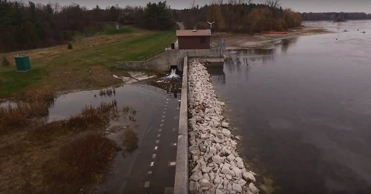
سد كيلسو
Kelso Dam was the first flood control dam constructed within the jurisdiction and was built in 1962. It operates in conjunction with the Hilton Falls Dam and Reservoir. It is operated to provide flood protection to downstream areas within the Town of Milton during spring melt, as well as rainfall and snowmelt events. Kelso Dam provides low flow augmentation in summer months to support aquatic habitat in the downstream Sixteen Mile Creek. It also allows visitors to Kelso to enjoy recreational opportunities like swimming and non-motorized boating.
هيلتون فولز دام
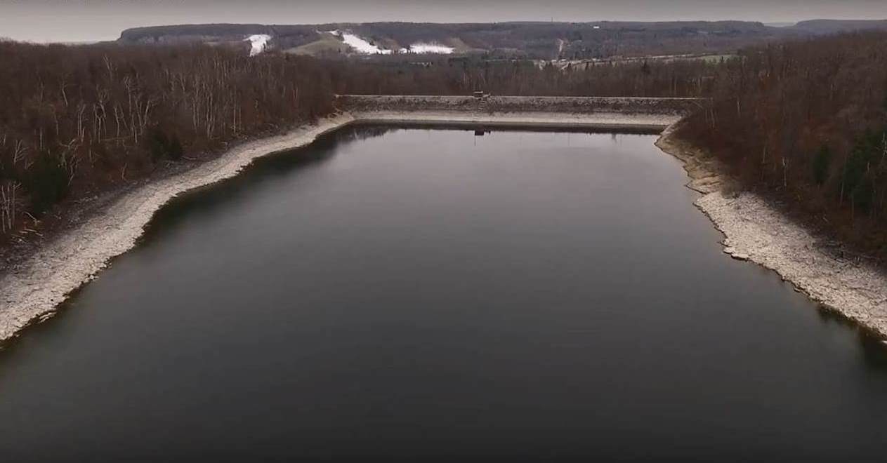
The Hilton Falls Dam and Reservoir was constructed in 1974. It operates in conjunction with the Kelso Reservoir to provide flood protection to downstream areas within the Town of Milton during spring melt, as well as rainfall and snowmelt events.. Hilton Falls is also used to augment flows into the Kelso reservoir during drier summer months by storing upstream runoff during the spring and releasing it at a pre-determined rate. The level of flood protection during winter months is quite high because when holding levels are lower, but the level of flood protection is reduced during summer, due to higher reservoir levels, which reduce available active flood storage.
سد ماونتسبرغ
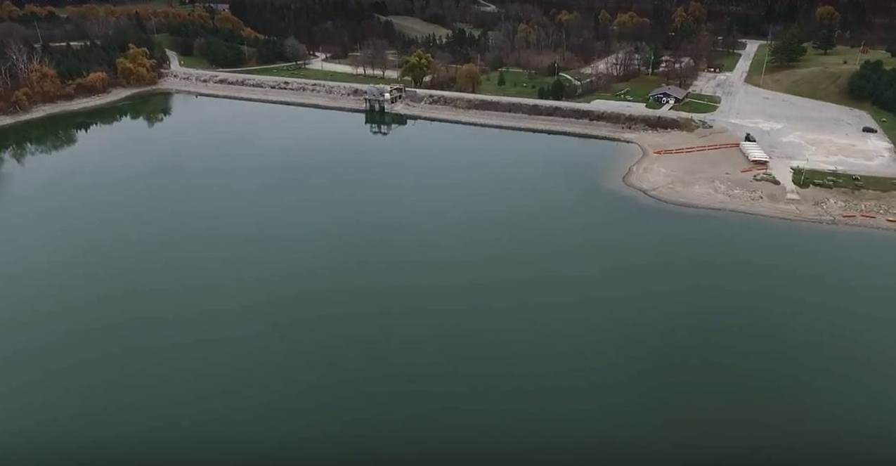
The Mountsberg Dam and Reservoir was constructed in 1967. It is operated to provide flood protection to downstream areas within Lawson Trailer Park and the Town of Carlisle during spring melt, as well as rainfall and snowmelt events. Mountsberg is also used to augment low flows in downstream Mountsberg Creek and the Bronte Creek system during drier summer months by storing upstream runoff during the spring and releasing at a pre-determined rate. The reservoir also provides recreational opportunities, like fishing and non-motorized boating.
Scotch Block Dam
The Scotch Block Dam and Reservoir was constructed in 1971. It is operated to provide flood protection to downstream areas within the villages of Mansewood and Hornby during spring melt, as well as rainfall and snowmelt events. Scotch Block is also used to augment flows in Middle Sixteen Mile Creek during drier summer months by storing upstream runoff during the spring and releasing at a pre-determined rate. The level of flood protection during winter months is quite high because when holding levels are lower, but the level of flood protection is reduced during summer, due to higher reservoir levels, which reduce available active flood storage.
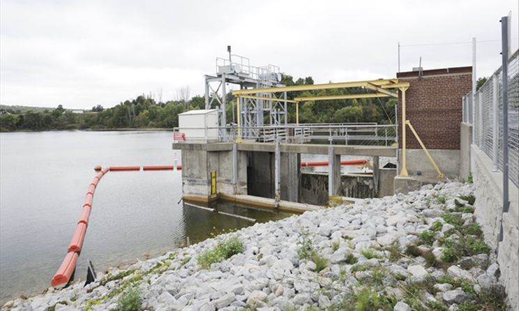
تعمل شركة Conservation Halton على تشغيل وصيانة ثلاث قنوات للتحكم في الفيضانات. تم بناء القنوات في أواخر 1960 و 1970 لنقل المياه عبر مجتمعاتنا وإلى بحيرة أونتاريو في أسرع وقت ممكن. منذ هذا الوقت ، تغيرت الطريقة التي نصمم بها مجتمعاتنا. اليوم ، تشمل مجتمعاتنا برك مياه الأمطار ومساحة لتدفق الجداول ، بشكل طبيعي ، بحيث يمكن تخزين المياه الزائدة وإطلاقها بمرور الوقت بعد حدث المطر.
هاجر رامبو
تم الانتهاء من قناة فيضان هاجر-رامبو في عام 1976 ويبلغ طولها حوالي 4 كم. ويهدف إلى تخفيف الفيضانات المحلية في المناطق السكنية داخل مدينة برلنغتون. يحول Hager-Rambo تدفق Hager و Rambo Creeks العلوي غربا إلى Indian Creek قبل أن يفرغ في بحيرة أونتاريو.
ميلتن
تم بناء قناة ميلتون للفيضانات على خمس مراحل ، آخرها في عام 1979. يبلغ طوله 3 كم وينقل مياه الفيضانات في Sixteen Mile Creek بأمان عبر منطقة وسط المدينة التاريخية في مدينة ميلتون.
موريسون-ويدجوود
كانت قناة موريسون-ويدجوود أول قناة فيضان بناها Conservation Halton في عام 1967 في مدينة أوكفيل. تمت إضافته في عام 1969. يبلغ طول هذه القناة ما يزيد قليلا عن 4 كم وتحول المياه من المناطق السكنية شمال طريق الملكة إليزابيث ، وغربا إلى Sixteen Mile Creek ، وبعيدا عن المناطق السكنية جنوب QEW.
تتمثل الخطوة الأولى للحد من تأثير أضرار الفيضانات داخل المجتمع في الحصول على خرائط تساعدنا على تحديد مخاطر الفيضانات بدقة. تعمل شركة Conservation Halton مع شركائنا للحد من مخاطر الفيضانات في مجتمعاتنا من خلال تحديث خرائط السهول الفيضية ، التي يزيد عمر بعضها عن 20 عاما. تساعدنا تحديثات الدراسات التقنية والنمذجة، باستخدام أدوات وتقنيات جديدة، على فهم مدى مخاطر الفيضانات بشكل أفضل. ومع تقدم استعراضات الخرائط وتحديثاتها، سيكون من الضروري إدخال تحسينات على رسم خرائط حدود التنظيم التقريبية، حيث يمكن تحديد مناطق خطرة أو خاضعة للتنظيم إضافية وإزالة بعضها.
كيف يمكنك المشاركة؟
الحفظ يشجع هالتون الجمهور على المشاركة في دراسات رسم خرائط مخاطر الفيضانات. توفر المشاركة العامة قدرا أكبر من اليقين والشفافية لبرنامج رسم خرائط السهول الفيضية ، وتستفيد من تلقي ملاحظات حول مستجمعات المياه من الأشخاص الذين يعانون من ظروف مستجمعات المياه هذه.
نستضيف جلسات مشاركة عامة حول دراسات رسم خرائط السهول الفيضية لإخطار الجمهور وأصحاب المصلحة بأن هناك دراسة تحدث في منطقتهم وتبادل المعلومات حول عملية الدراسة ومسودة تحديثات رسم الخرائط للمراجعة والمدخلات. يتم نشر إشعارات دراسة رسم خرائط السهول الفيضية والتحديثات حول المشاركة العامة في الصحف المجتمعية ونشرها على موقع Conservation Halton على الويب ووسائل التواصل الاجتماعي. يمكنك أيضا طلب إضافتك إلى قائمة جهات الاتصال عبر البريد الإلكتروني للدراسة لتلقي إشعارات مباشرة.
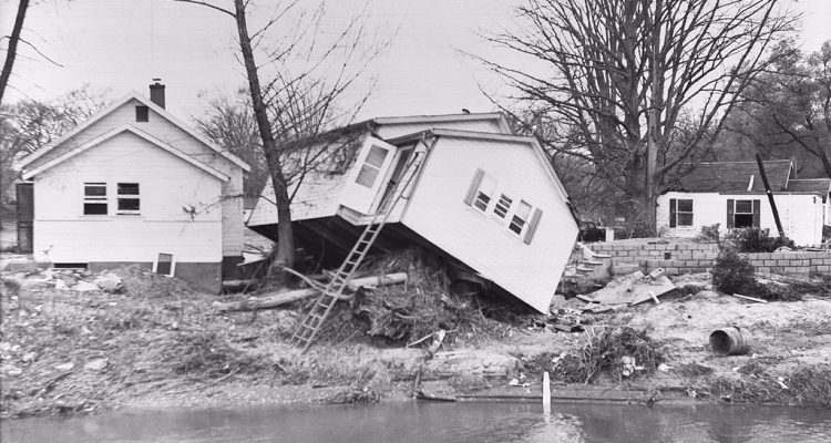
Hurricane Hazel in 1954, and the catastrophic flooding that it caused, was the driving force for the creation of conservation authorities in Ontario. Within the province, 81 people lost their lives and 4,000 families were displaced from their homes. Following the destruction and devastation of Hurricane Hazel, regulations and policies to prevent home construction and other development in ravines and floodplains were implemented to protect us from similar tragedy.