Current Rivers & Streams Flood Status: Normal
Spring Safety Message: Exercise Caution Near Waterways
Conservation Halton Flood Terminology
The following is the flood and water safety terminology that is used by Conservation Halton, as well as other conservation authorities throughout Ontario, and Ministry of Northern Development, Mines, Natural Resources and Forestry. The terms were developed by a committee of representatives of conservation authorities, Conservation Ontario, the Ministry of Northern Development, Mines, Natural Resources and Forestry and Environment Canada, to ensure alignment with terminology used by other agencies such as the Weather Network.

عام: حالات عام حدود کے اندر ہوتے ہیں۔ کسی سیلاب کی توقع نہیں ہے۔
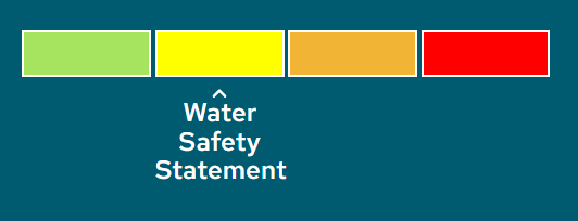
Watershed Conditions Statement – Water Safety: High flows, unsafe banks, melting ice, or other factors could be dangerous for recreational users such as anglers, canoeists, hikers, children, pets, and others. Flooding is not expected.

Watershed Conditions Statement – Flood Outlook: Early notice of the potential for flooding based on weather forecasts calling for heavy rain, snow melt, high wind, or other conditions that could lead to high runoff and/or cause ice jams.

Flood Watch: Flooding is possible in specific watercourses or municipalities. Municipalities, emergency services, and individual landowners in flood-prone areas should prepare.
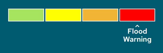
Flood Warning: Flooding is imminent or already occurring in specific watercourses or municipalities. Municipalities and individuals should take action to deal with flood conditions. This may include road closures and evacuations.
Additional Resources
The GTA Flood Group has prepared the following Ice Management Info Sheet based on the River Ice Manual, MNR 1984.
Municipal Role vs. Conservation Authority Role: Under the Emergency Management and Civil protection Act (Ontario Regulation 380/04), municipalities have the primary responsibility and authority for response to flooding and flood emergencies, and also for the welfare of residents and protection of property. While Conservation Authorities do not engage in ice management directly, they do operate a flood forecasting and warning program and can offer advice for ice jam prevention and mitigation.
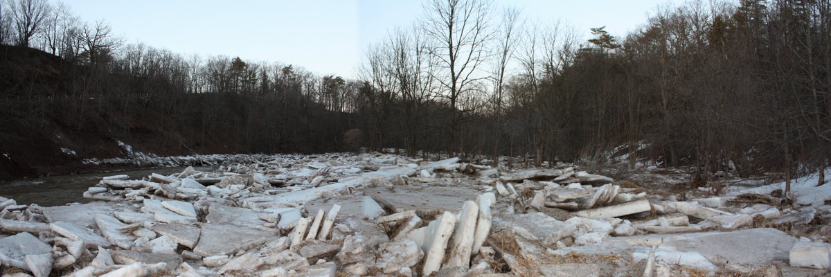
Preventing ice jams from occurring in the first place is the best way to prevent flooding. Ice jam flooding can be preventing only by understanding the case of ice breakups and by knowing how to predict when break-up will occur.
Ice Jam Genesis
Each situation and location where ice jams form is unique. However, there are a number of factors generally common to all ice jams and there are many similarities that can be found in the conditions prior to the jams, wherever they may occur.
Ice jam floods have historically been immediately preceded by rapid changes in weather and by colder than average winters. Likely sites for ice jams include areas where a widening or deepening of the river channel causes sudden reductions in the water velocity, and/or where there are sudden changes in the direction of flow, such as constrictions in the river channel or at bridges and their approaches.
Initial breakup is based on two factors; the number of accumulating degree-days of melting and the amount of precipitation during the melt. If the subsequent rise in water level is sufficient, it will pry the ice cover loose from the river banks; but it would not necessarily move the ice downstream or break it up. Ice cover breakup depends on the velocities created or the topography of the river, together with such restraints as islands, bends, or ice booms.
Summary of Predictive Techniques:
- Problems can be expected if there is an uninterrupted thaw of approximately twenty degree-days of melting during a very short period of time — 3 to 5 days.
- Problems are likely in the event of precipitation of 12 mm or more in 24 hours, especially if this follows several days of melting, if the ground is still frozen, or if the watershed has a large urban area.
- Rising water levels and increasing velocities can case breakup — a preliminary indication of possible trouble. A rise of one metre in 24 hours often causes breakup, and will always cause breakup where velocities are greater than 1.0 m/second.
- There is a specific breakup flow for every river, where large portions of the ice cover disintegrate. From limited information, it appears that the breakup flow is about 60% of the 100-year flood flow. Due to variations in ice quality and weather sequences, this percentage may vary from 50% to 70%.
- Partial breakups and local jams may occur due to broken pieces of ice accumulating in front of, and/or underneath an ice cover, causing it to break by bending.
Preventative and Remedial Measures
It is best to approach ice jam prevention with caution. Without a properly formulated plan, including a safe storage area such as a lake, many preventative techniques can simply move ice jams—creating larger problems downstream. Wherever possible, ice breaking should begin at the river mouth and work upstream.
Preventative and remedial processes include:
Weakening and/or breaking of ice
|
Control
|
Ice removal
|
(Details on each technique are available from River Ice Manual, MNR 1964)
When is intervention appropriate?
- When there is a sufficient storage area and intervention will not create jams downstream.
- When ice removal is possible without damaging the riverbank or the environment.
What are some alternatives to intervention?
- Sandbagging
- Emergency planning (e.g., evacuations)
Ice Blasting
Blasting is used to break an ice cover into floes that can be transported by the water downstream, or to weaken a solid ice cover prior to the arrival of upstream ice. The explosive charge is usually placed in the water underneath the ice.
The ideal time to release a jam is just after it has formed, starting at the outlet and moving upstream. If the flow has dropped, blasting the jam will be ineffective due to the lack of sufficient water to carry the loosened ice downstream.
Blasting ice jams is rarely effective and is dangerous to the blasting crew and neighbouring property. There are less expensive and more effective techniques to remove ice that have no environmental impacts, are safer for crews, and do not result in uncontrolled releases of river ice.
Your conservation authorities are here to help.
Please let your local conservation authority know of any preventative or remedial ice jam measures that your municipality may be undertaking. For more information or advice, please contact your local conservation authority:
- Conservation Halton: (905) 336-1158
- Lake Simcoe Region Conservation Authority: (905) 895-1281
- Toronto & Region Conservation Authority: (416) 661-6514
- Credit Valley Conservation Authority: (905) 670-1615
- Central Lake Ontario Conservation Authority: (905) 579-0411
- Ganaraska Region Conservation Authority: (905) 885-8173
- Nottawasaga Valley Conservation Authority: (705) 424-1479
- Kawartha Conservation: (705) 328-2271 or 1-800-668-5722
Flood Forecasting and Operations Program
Conservation Halton provides a flood forecasting and operations program to reduce the risk of property damage and loss of life due to flooding. When flooding is possible or about to occur, Conservation Halton issues flood messages to municipal officials, emergency medical services, police, school boards and media. It is the responsibility of municipal officials to warn local residents.
Conservation Halton is responsible for the maintenance and operation of four major flood control dams (Kelso, Hilton Falls, Scotch Block and Mountsberg) and more than 12 kilometers of flood conveyance channels (Sixteen Mile Creek through Milton, Morrison-Wedgewood diversion in Oakville and the Hager-Rambo diversion in Burlington).
روابط:
گلین فارمر
منیجر، سیلاب کی پیش گوئی اور کارروائیاں
موبائل: 647-458-1046
ای میل: gfarmer@hrca.on.ca
Shelly Datseris
Manager, Communications and Marketing
Mobile: 905-208-0030
Email: sdatseris@hrca.on.ca